Monday, June 29, 2020

El Hormiguero (Campeche)

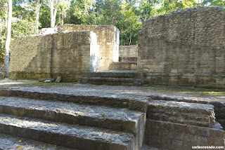
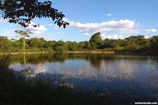
Located about 45 kmfrom of Xpujil, to the very south of the state of Campeche and just a few kilometers lay the ruins of El Hormiguero (meaning ant hill in spanish) whose original name I believe has been lost to history. Due to its isolated location this site is seldom visited by tourists, which is a shame as it boasts some really impressive structures and is particularly good for spotting wild-life. Although at one time an eco-archaeological camp seems to have been set up for visitors, by the time I visited in 2018 with my good friend Zane, the camps seemed long abandoned. The road to access the site was fairly rough, though as we visited before the rainy season it was still fairly accessible. That being said there was very little in the way of signage so we had to depend almost entirely on google maps.

The site was first reported by Karl Ruppert and John Dennison in the thirties, thought it was not until the late 70s that excavations first began. Archaeologists suggest that the site reached its height fairly late in the the VI century, well into the late classical/early post classic. Its most striking feature is the monster of the earth facade which is flanked by rounded towers and stairways. Although this region is ofcourse well known for such features, it is interesting and impressive to see such a mask mounted a top such a large platform. There are another five large scale structures at the site thought for they still lay underneath fairly thick vegetation. There is also evidence of restored habitational structures which at least in 2018 seemed be in fairly good shape. Let me know if have visited the site recently and/or if you have any further information about it. Cheers!





Friday, June 19, 2020

Awesome suprise in Paraiso, Maxcanu.

Often times when I am speaking with someone who does not know much about Mesoamerica or the Maya I am often left with the impression that they think that archaeological remains are much more scarce than they really are. This is to say they figure there are perhaps about three to five or so archaeological sites of settlements of any real importance and then a few scattered rather insignificant sites. They are usually when I tell them I have visited well over 100 Mayan archaeological sites, and that many of them are the remains of quite large sites complete with plazas and very sizable construction. This is all to say (without bragging) that I am fairly well travelled in the region. That being said… like just about everyone I often come across information regarding a site I somehow have never heard about.


Some time ago, I don't recall how, I came across a website with some info regarding a church located in the municipality the town of Paraiso Yucatan (which I had never even heard of) in the municipality of Maxcanu. From the couple of photos on the website, I could see that who ever built or remodeled this church had used what appeared to be Mayan stelae as adornments. While its by no means that rare to find evidence of pre hispanic art/architecture in churches in the region, these details are usually limited to a small carved detail here, or some hieroglyphic writing there. Not in Paraiso, what I seemed to be seeing where entire stelae and other fairly significant sculpted reliefs being displayed quite prominently. As you can probably tell from the photos bellow, they are very Puuc (which is obvious given the their period/location) and also of a style you would expect to find in sites such as Oxkintok. Intrigued, I found a write up about a project at this very site and found out that the stelae were in fact authentic and had been originally found in the area surrounding an hacienda called Santa Barbara. The report can be found here: http://www.famsi.org/reports/00039es/00039esStanton01.pdf


Anyway, according to the document these remains came to the attention of archaeologists in the 1960s as locals began to report pillaging. It is still unclear to me what exactly was the state of these artifacts or how/when they found a home on the facade of this church… but I am sure its a fascinating story. If you know anything about this please give me a shout, I would love to know more. In any case here are some pictures of said church and its marvelous idiosyncratic decorations! Quite an example of religious syncretism would you say? The photos are all my own and from February of 2020.


Monday, June 15, 2020

Santa Rosa Xtampak

Heaven knows how many weeks in to this pandemic, yesterday I found myself today going through my photos from last year and realized that I haven't blogged about a bunch of archaeological sites I have visited recently. Since the “I have no time” argument seems fairly weak at this point, I thought I would start up again.

About a year or so ago my father and I made our way to Santa Rosa Xtampak. We had been wanting to visit the site for some time but knew that the access to the site was fairly difficult. we were not wrong! A quick search on google maps informed us that the trip each way would take just over 3 hours, but it turns out that was quite optimistic (as google maps often is). Located to the west of Bolonchen and Hopelchen, the road to Santa Rosa Xtampak is not much more than a 30 some kilometer dirt road through corn and squash plantations. Another thing you will notice in the region is the presence of several fairly large Mennonite farms.There are a few small communities just off the detour road to Santa Rosa, but there are no services to be had. This region is known as the "chenes" both because the names of most of the towns in the region end in "chen" and because of the Mayan architectural style of the same name which is characteristic of pre-hispanic cities in the area.

It is widely believed that Santa Rosa Xtampak was likely the Mayan capital of the Chenes region. The site features a series of interconnected plazas and patios, ballcourts, a sacbe and several multi level structures. area of the Chenes region covers approximately 2500 km2, and the city of Santa Rosa Xtampak had an area of about 30 km 2. Though the city was established in the pre classical period sometime in the 3rd century BCE, its population seems to have reached its zenith between the 5th and 8th centuries CE. This period also witness the cities last large scale construction boom and the forging of political and military ties with the city of Uxmal. One of the most recognizable structures of the city is simply known as "El Palacio". It is likely that this structure had multiple purposes such as ceremonial and residential areas. The structure boasts three floors and 46 rooms which are interconnected by a series of passageways and stairs. Another interesting feature of the site is its “monster of the earth” facade, although its state of preservation is rather poor when compared to those found at sites such as Chicana or Hormiguero.

If you are interested in visiting the site I would recommend to bring along plenty of water and make sure you fill up the tank before departing from Merida or Campeche. Another good option would be to visit the site after having spent the night in the area surrounding Uxmal. Another recommendation is to avoid visiting during the rainy season as the already very fragile road is easily flooded!